Property Record
2349 Gravel Springs Rd, Buford, GA 30519

Current Lease Availabilities
NEARBY LISTINGS FOR SALE OR LEASE
Property Detail
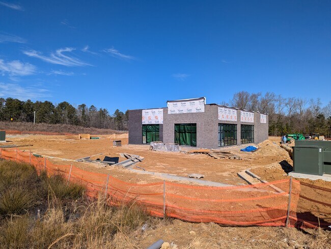
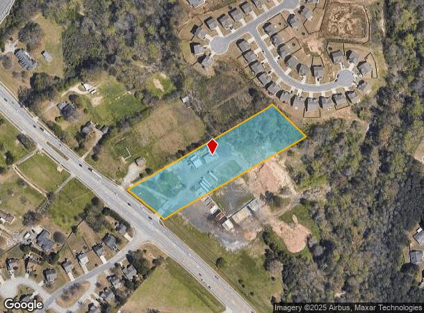
2349 Gravel Springs Rd
Atlanta-Sandy Springs-Roswell, GA
Gravel Springs
7-100-091
GRAVEL SPRINGS RD
Horticulturegrowinghousesagricultural
Gwinnett
AE
Georgia
13135C0036F
99
2025
3.72 AC
2025
Suwanee/Buford
050612
Atlanta
3,672 SF
DEMOGRAPHICS near 2349 Gravel Springs Rd
1 Mile
3 Mile
5 Mile
2024 Total Population
6,009
62,798
150,180
2029 Population
6,279
66,038
158,446
Pop Growth 2024-2029
+ 4.49%
+ 5.16%
+ 5.50%
Average Age
38
39
38
2024 Total Households
1,925
19,804
47,914
HH Growth 2024-2029
+ 4.47%
+ 5.41%
+ 5.66%
Median Household Inc
$99,032
$100,872
$98,515
Avg Household Size
3.10
3.10
3.10
2024 Avg HH Vehicles
2.00
2.00
2.00
Median Home Value
$302,599
$346,524
$332,931
Median Year Built
2003
2003
2002
Nearby Places
Map Layers
Map Styles
 Street
 Aerial
- Restaurants
- Banks
- Shops
- Fitness
- Groceries
Nearby Properties
Address
Land Use
TOTAL SIZE
Lot Size
Zoning
Address
Land Use
TOTAL SIZE
Lot Size
Zoning
1,435,842 SF
83.47 AC
C2
Address
Land Use
TOTAL SIZE
Lot Size
Zoning
473,883 SF
85.71 AC
RA200
Address
Land Use
TOTAL SIZE
Lot Size
Zoning
1,113,809 SF
57.50 AC
M1
Address
Land Use
TOTAL SIZE
Lot Size
Zoning
403,129 SF
126.91 AC
RA200
Address
Land Use
TOTAL SIZE
Lot Size
Zoning
394,831 SF
16.37 AC
RM24
Address
Land Use
TOTAL SIZE
Lot Size
Zoning
684,003 SF
60.84 AC
M1
Address
Land Use
TOTAL SIZE
Lot Size
Zoning
379,178 SF
39.27 AC
RM10
Address
Land Use
TOTAL SIZE
Lot Size
Zoning
619,498 SF
51.81 AC
M1
Address
Land Use
TOTAL SIZE
Lot Size
Zoning
335,641 SF
28.90 AC
RM10
Address
Land Use
TOTAL SIZE
Lot Size
Zoning
282,431 SF
23.20 AC
RM13
Address
Land Use
TOTAL SIZE
Lot Size
Zoning
348,358 SF
7.80 AC
H7
Address
Land Use
TOTAL SIZE
Lot Size
Zoning
335,438 SF
10.94 AC
MUR
Address
Land Use
TOTAL SIZE
Lot Size
Zoning
121,100 SF
3.74 AC
RM24
Address
Land Use
TOTAL SIZE
Lot Size
Zoning
192,805 SF
12.40 AC
RM24
Address
Land Use
TOTAL SIZE
Lot Size
Zoning
323,877 SF
29.14 AC
C2
Address
Land Use
TOTAL SIZE
Lot Size
Zoning
223,096 SF
6.06 AC
MUR
Address
Land Use
TOTAL SIZE
Lot Size
Zoning
353,241 SF
33.16 AC
C2
Address
Land Use
TOTAL SIZE
Lot Size
Zoning
280,168 SF
29.08 AC
M1
Address
Land Use
TOTAL SIZE
Lot Size
Zoning
233,266 SF
17.39 AC
RA200
Address
Land Use
TOTAL SIZE
Lot Size
Zoning
352,952 SF
16.97 AC
RM10
Address
Land Use
TOTAL SIZE
Lot Size
Zoning
158,307 SF
26.77 AC
R75
Address
Land Use
TOTAL SIZE
Lot Size
Zoning
162,013 SF
20.23 AC
RA200
Address
Land Use
TOTAL SIZE
Lot Size
Zoning
138,229 SF
7.97 AC
OI
Address
Land Use
TOTAL SIZE
Lot Size
Zoning
23,126 SF
88.56 AC
RA200
Address
Land Use
TOTAL SIZE
Lot Size
Zoning
124,425 SF
20.73 AC
RA200
Address
Land Use
TOTAL SIZE
Lot Size
Zoning
329,765 SF
33.06 AC
C2
Address
Land Use
TOTAL SIZE
Lot Size
Zoning
131,160 SF
17.89 AC
RA200
Address
Land Use
TOTAL SIZE
Lot Size
Zoning
110,356 SF
20.42 AC
RA200
Address
Land Use
TOTAL SIZE
Lot Size
Zoning
225,640 SF
5.23 AC
MUR
Address
Land Use
TOTAL SIZE
Lot Size
Zoning
97,824 SF
13.71 AC
M1
The World's #1 Commercial Real Estate Marketplace
Connect with us
© 2025 CoStar Group
The information above has been obtained from sources believed reliable. While we do not doubt its accuracy we have not verified it and make no guarantee, warranty or representation about it. It is your responsibility to independently confirm its accuracy and completeness. Any projections, opinions, assumptions, or estimates used are for example only and do not represent the current or future performance of the property. The value of this transaction to you depends on tax and other factors which should be evaluated by your tax, financial, and legal advisors. You and your advisors should conduct a careful, independent investigation of the property to determine to your satisfaction the suitability of the property for your needs.